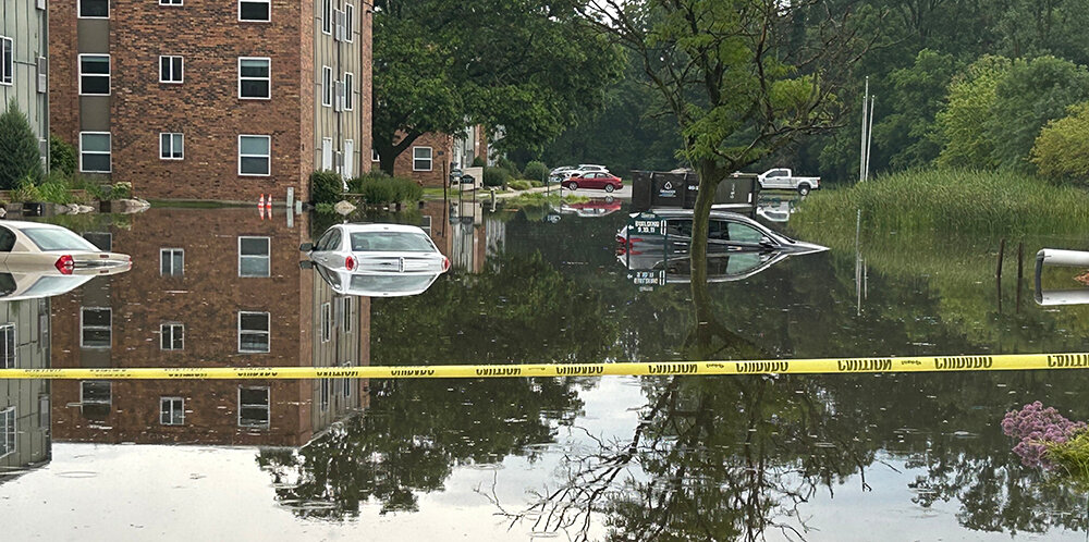
On the morning of June 17, Richie Waters and his partner, Miles Abdal, left their apartment at The Quarters in East Lansing to find the latter’s car mostly covered in water in the parking lot.
Abdal was planning on driving Waters to work that morning, but the damage totaled his car. Abdal was fortunate enough to have an insurance policy that covered the loss, but the pair decided to take additional precautions.
Weeks later, when they heard about another heavy rainstorm expected to arrive early July 9, the pair parked the car farther away, where it would be safe from flood damage.
They were thankful for that foresight. Spurred by Hurricane Beryl, last week’s storm brought as much as 5 inches of rain to East Lansing in two hours and approached 7 inches by day’s end. At its peak, Waters estimated that the deluge filled roughly 60% of The Quarters’ parking lot. At least one car was a few inches short of submerged.
While last week’s flooding didn’t come close to matching the intensity of a historic 1975 flood that led to some of the highest water levels on record for the Grand and Red Cedar rivers, local experts say that climate change could result to an increased probability and frequency of major flooding.
Wonmin Sohn, an assistant professor in Michigan State University’s landscape architecture program, said that while Greater Lansing isn’t generally seen as a high-risk flood area, “climate change has made accurate precipitation prediction more challenging, increasing the possibility of unprecedented flooding even in cities previously considered safe from such events.”
Hurricane Beryl, which began June 29 and peaked July 2, is a historic outlier supporting this theory. The National Oceanic and Atmospheric Administration cited it as “the earliest Category 5 hurricane observed in the Atlantic on record,” in part due to warmer-than-average oceanic temperatures.

The fallout of this unusually early hurricane could be traced from Houston up through southeastern Michigan, where notable local damages included a collapsed roof at Kositchek’s Menswear in downtown Lansing and $15,000 in losses at Forster Woods Adult Day Center in East Lansing.
Sohn said there’s good reason to believe that these high-intensity, short-duration storms may become more common as temperatures continue to rise through global warming. So far in 2024, with February being the lone exception, she said Michigan has “consistently shown early signs of above-average precipitation and an abnormally warm winter and summer.”
“The transition from El Niño to La Niña, beginning in early 2024 and continuing through the summer, has contributed to unusually high rainfall and localized intense precipitation events across the Great Lakes region. This shift has increased the complexity and unpredictability of precipitation,” Sohn said.
The trend goes far beyond the United States, with Sohn noting that the Intergovernmental Panel on Climate Change “predicts more intense and heavier storm events, leading to increased severe flooding.”
“For the Great Lakes region, projections indicate that flooding will intensify and be coupled with extended dry periods,” Sohn said. “By the end of the century, spring and fall are forecasted to bring substantially more severe and recurrent storms, amplifying the strain on healthcare services and public infrastructure.”
As this process plays out, Sohn said Michigan’s humid continental climate — which typically yields warm summers and fairly cold winter months — is projected to shift toward even warmer-than-average year-round temperatures.
“Summer warming is expected to lead to higher evaporation rates, more intense heat waves and longer periods of drought. Conversely, winters, while still cold, are projected to become milder with less snowfall and more rain,” she said.
“These changes will significantly impact flooding patterns in Michigan. Warmer summers with intense rain events will lead to increased runoff, overwhelming stormwater systems and causing urban flooding. Milder winters with more rain instead of snow will contribute to more frequent winter and spring floods as snowmelt decreases but rainfall increases,” Sohn added.
Nicole McPherson, a Lansing city engineer who joined the city last year after seven years with the city of East Lansing, agreed, noting that major rainfall events are “getting more unpredictable and intense.”
Most municipal stormwater management systems are typically designed to withstand a 10-year storm, or one that McPherson said has a 10% probability of happening in any given year. According to the City of East Lansing’s website, the storm that totaled Abdal’s car in June featured rainfall that “occurred predominantly over a period of one to two hours, qualifying it as a 200-to-1,000-year storm event under current classification systems.”
McPherson said it was fair to describe a 100-year storm, which has a 1% chance of occurring each year, as a “major” event.
“I’m going to put a big ‘but’ on this, though, because we’re seeing more and more of these 100-year storm events,” she added.
Cliff Walls, East Lansing’s environmental sustainability and resiliency manager, the city is working on new standards for predicting the likelihood of floods.
Walls cited data showing a 75% increase in short-duration storm events — or heavy showers that can range from a few hours up to a full day — for the area between 1949 and 2023.
“There’s a finite amount of hydraulic capacity in the drainage infrastructure. So, when it comes down fast, like in this one- or two-hour storm we saw last Tuesday, that’s more problematic for drainage infrastructure, because it’s not something that systems have historically been built for,” Walls said.
To prepare for and potentially mitigate the impact of major floods, Walls and his team started developing a “wet weather resiliency plan” in January. Funded through a $600,000 state grant, the three-year program aims to draw from scientific data, resident input and other factors to design an action plan to help the city stay ahead of the curve.
“Part of our plan is to identify what a new standard should be in East Lansing,” Walls said about the aforementioned 10-year and 100-year NOAA benchmarks. “We want to make sure that our design standards and infrastructure reflect where we think we’re going to be in the future so that we’re equipped for the storms of tomorrow.”
Just over a week after the most recent floods, many Greater Lansing residents and business owners are still dealing with the fallout.
Forster Woods Adult Day Center CEO Jennifer Putmon said she had to close for three days to assess damages after portions of the facility were filled with up to 2 inches of water. It reopened Monday at a limited capacity.
“Unfortunately for us, insurance covers nothing, because our damages included groundwater, which is automatically excluded,” Putmon said.
She started a GoFundMe page to help cover the center’s losses, and so far 38 donors have contributed more than $5,000.
Putmon commended the city of East Lansing for a prompt response.
For his part, Waters said his concerns over potential flooding would likely influence where he decides to live in the future.
“The flooding situation has been pretty wack, to put it succinctly. In the future, I’ll probably be a lot more mindful of where the place I am living is in relation to the sea levels,” he said with a laugh.
— TYLER SCHNEIDER


Support City Pulse - Donate Today!
Comments
No comments on this item Please log in to comment by clicking here